Announcement

Interviewed on the MapScaping Podcast

20200312_092345.jpg

Earlier this winter I had the honor of being asked by Daniel O’Donohue of the MapScaping podcast to be interviewed about all things QGIS. I was really impressed with his attention to detail. With his suggestion I went out and bought a better microphone, a stand, a pop filter and some mic covers. These just help improve the sound quality. As a podcast fanatic/addict it was fun to learn more about podcasting gear.

I think it was worth it. I’m really happy with the way it came out, and it was interesting to be on the other side of podcasting for an hour!

The episode just dropped this morning. You can give it a listen below, or find the MapScaping podcast via your favorite podcast provider.

QGIS 2.8.1 Released

This week the next stable version of QGIS was released. It is being called QGIS version 2.8 ‘Wien‘. Wien is German for ‘Vienna‘ which was the host city for the QGIS developer meetings in 2009 and 2014.

QGIS 2.8 Splash Page

Recently a new version of QGIS has been released every four months. This rapid pace of development has its pros and cons. On the plus side, the software is rapidly growing and improving. On the con side it has made it difficult to maintain documentation. It has also been an issue for people working on large projects. They have had to deal with the software changing every four months.

QGIS 2.8 is a special release because it is the first in a series of long-term releases (LTR’s). The idea is that one release per year will be an LTR. This means that the LTR release will be supported and available for download for one year. This way people needing stability can use this until the next LTR is released a year from now.

Some of the highlights are:

  • Numerous bug fixes and stability improvements
  • QGIS Browser is more responsive
  • Ability to select the units in the Measure tool
  • Improvements to editing: better control of snapping and a new suite of Advanced Digitizing tools
  • Improvements to the Map Composer such as better control over coordinate graticules and map rotation.
  • Symbology improvements such as filling polygons with raster images, ability to have multiple styles per layer.

The detailed list of new features can be found in the QGIS Virtual Change log: http://www2.qgis.org/en/site/forusers/visualchangelog28/index.html

Visit the download page and take the new version for a spin. Remember you can install it on Windows, Mac and Linux!

Announcement: New Community Health Mapping Blog

Community Health Maps - Information on Low Cost Mapping Tools for Community-based Organizations

Kurt Menke, of Bird's Eye View, is contributing to a new FOSS4G related National Library of Medicine blog: Community Health Maps. The goal of the blog is to provide information about low cost mapping tools that can be used by community based public health organizations.  Perhaps you’ve seen the potential uses of mapping in public health, but are overwhelmed by the technology and/or simply too busy to pursue it.  I hope this blog will facilitate the use of GIS mapping for those that fall into this category.  I also hope to support those already engaged in mapping and enhance their community mapping initiatives, even if they may be using other tools.  The blog will be a mixture of mapping apps/software reviews, best practices, and the experiences of those who have successfully implemented a mapping workflow as part of their work. Training materials developed in 2013 are also available.

2013 Year End Recap

The summer and fall went by so quickly! Unfortunately this blog necessarily took a backseat to the actual work. Thankfully the holidays have given me time to reflect on 2013. Professionally it was a fantastic year filled with great projects. Below are some of the highlights, in no particular order.  

  •  ~400 maps produced
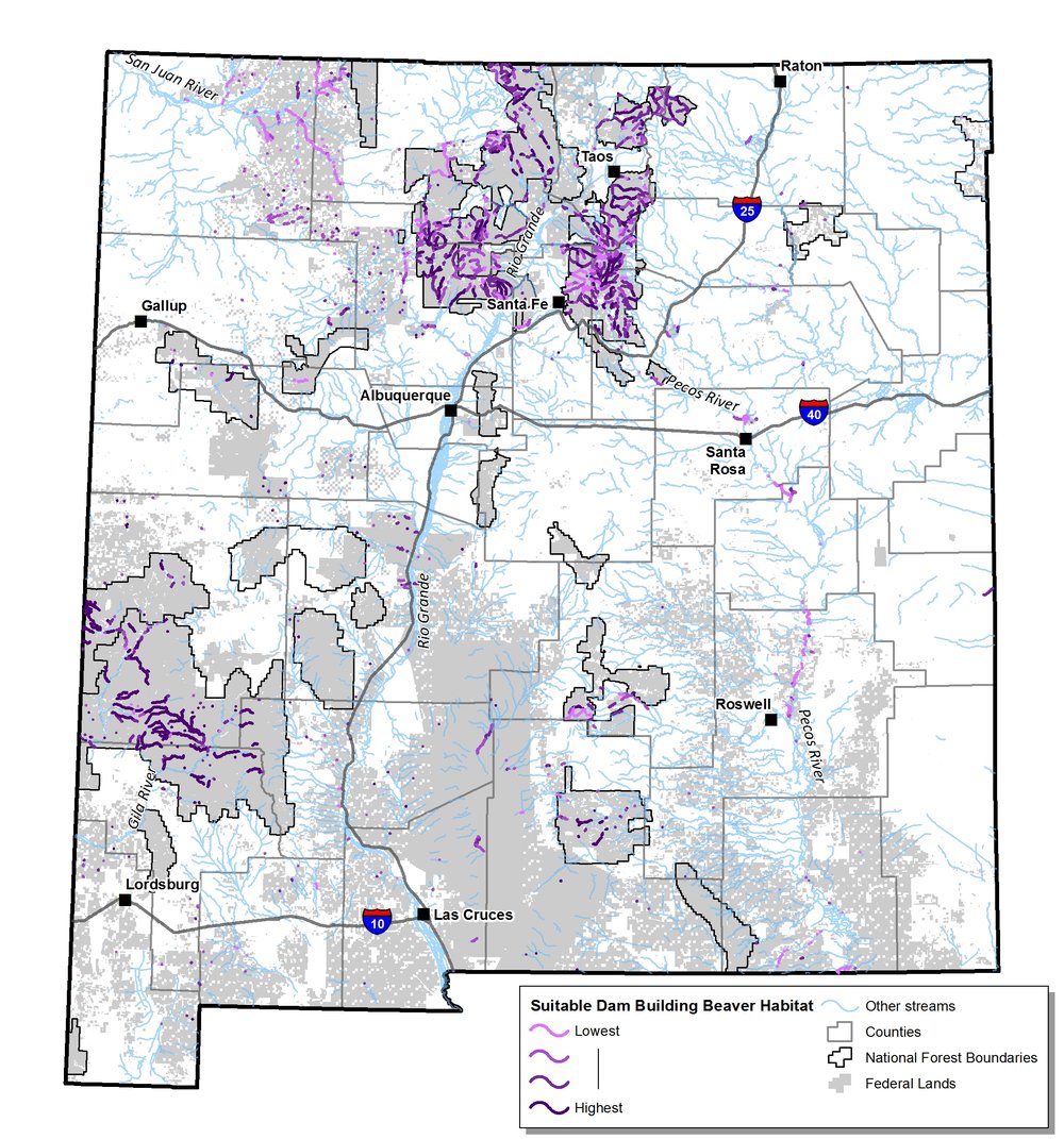
  • Modeled potential and suitable beaver habitat in New Mexico
  • Traveled to Seattle, WA and Honolulu, HI to train people in an open source data collection workflow
  • Taught the 5th installment of the Introduction to Open Source Software and Web Mapping at CNM...the best one yet!
  • Attending FOSS4G NA in Minneapolis, MN
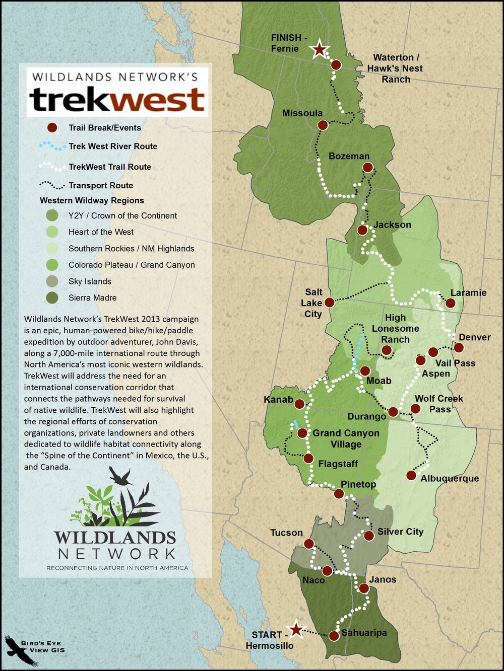
  • Supporting the Wildlands Networks TrekWest with route maps
  • Applied GIS to a wide variety of topics: wildfire, wildlife habitat protection, public health, wilderness proposals, travel management analysis, water rights, industrial noise, and parcel mapping.

Suitable Beaver Habitat

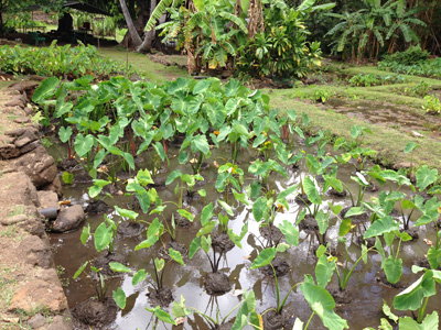
A tour of the Moana Lo'i (tarot field) and native Hawaiian permaculture

TrekWest Route map

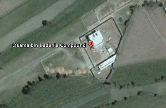
Will the real Osama Bin Laden compound please stand up.

In the hours after the announcement of Bin Laden's death people scrambled to Google Earth to find the location of Abbottabad, Pakistan and the compound. There were several incorrect guesses, like the example I found below, and posted Sunday night.

Part of the issue was that until yesterday the imagery Google had for the area was acquired in 2001, years before the compound had been built.  Yesterday Google updated their imagery to data acquired on June 14, 2005 (ZDNet).  In the 2005 data (below) the compound can be seen in an unfinished state.

Below is an image of the compound in it's current state from the CIA.

Bills introduced which would kill the Game & Fish Endangered Species program by eliminating their ability to use federal funds.

HB 567 - STATE RESPONSIBILITY FOR ENDANGERED SPECIES (Rep. Zachary Cook) – This bill would amend the Wildlife Conservation Act, requiring the state to take primary responsibility for listing, protecting, and managing Threatened and Endangered Species in New Mexico.  It would remove authorization for the Commission and the Department to consult with, assist, or enter into agreements with federal agencies concerning threatened or endangered species, and would require a complete investigation process for including any species already listed federally (the Commission could no longer adopt the federal list.)  Identical to SB 565.  Click here to read bill.

SB 565 - STATE RESPONSIBILITY FOR ENDANGERED SPECIES (Sen. William Burt) – This bill would amend the Wildlife Conservation Act, requiring the state to take primary responsibility for listing, protecting, and managing Threatened and Endangered Species in New Mexico.  It would remove authorization for the Commission and the Department to consult with, assist, or enter into agreements with federal agencies concerning threatened or endangered species, and would require a complete investigation process for including any species already listed federally (the Commission could no longer adopt the federal list).  Identical to HB 567.  Click here to read bill.

CALL THE HOUSE ENERGY & NATURAL RESOURCES COMMITTEE MEMBERS AND URGE THEM TO VOTE "NO".

  • Brian F. Egolf, 505-986-4423
  • Antonio Lujan, 505-986-4435
  • Miguel P. Garcia, 505-986-4327
  • Roberto "Bobby" J. Gonzales, 505-986-4425
  • Al Park, 505-986-4413
  • Richard D. Vigil, 505-986-4242

ESRI International Conservation Mapping Competition

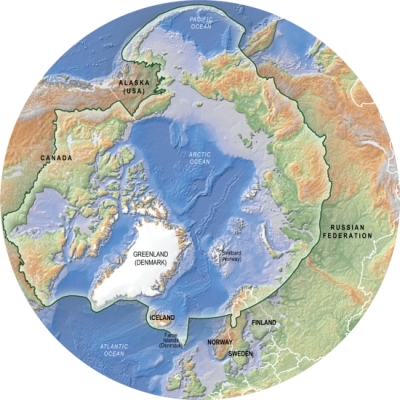
The Conservation of Arctic Flora and Fauna is a working group under the Arctic Council, for the countries of Russia, Denmark, USA, Canada, Sweden, Iceland, Norway and Finland and indigenous peoples.

Created in association with Esri and the Society for Conservation GIS (SCGIS) to bring special recognition to those involved in conservation initiatives, the International Conservation Mapping Competition is open to all nonprofit conservation groups and the individuals who support them.