My Business
I launched my business full-time in 2008 with the mission to use the technology to help make the world a better place. Ecology and conservation work is a steady focus, as is using FOSS tools. My reasons for the latter are many. The community aspect of FOSS projects aligns with my general sensibilities and ethics. On the practical side, there’s the fact that I can fund new features helpful to my day-to-day. There is the lack of license fees, plus I have the freedom to have my clients install and work with the same software I’m using. Until recently I’ve also have a single seat Esri license for those moments when business demands it. This is simply due to the reality that many contracts require data be delivered in proprietary Esri formats, a model be built in the Esri Model Builder, or contracts requiring an analysis be done and delivered with Esri software. These requirements are common among U.S. municipalities and state agencies.
For example, I really enjoy the challenge of modeling species habitat and migration corridors. When you throw climate change into the mix to estimate species range shift by e.g., 2100, it’s a fascinating puzzle to solve. Last month New Mexico DOT announced an exciting RFP to conduct a statewide wildlife corridor assessment. This is something I’ve been trying to get funded for many years. It unfortunately specified the work be done using specific ArcGIS tools. Such a buzzkill.
One of the best marketing strategies Esri has developed is giving their software away for free. A few years ago they gave free ArcGIS Online accounts to all the K-12 schools in the U.S. Similarly there is a Conservation Grant Program at Esri. In 2002 I used it to get a local conservation NGO an Esri license which they still have today. Back then there were fewer options. Today that would seem ridiculous to me. Through this program most of the U. S. based conservation NGO’s have free or greatly reduced Esri licenses. This is also true for tribes. My perception is that many see this as altruistic, but clearly Esri is not benign. It is simply brilliant marketing. Due to this most conservationists are Esri purists. However, I have always felt that NGO’s doing that type of work should be using software that aligns with their organizational ethics. They should be using open data with community produced software whenever possible.
Conservation
I have ruminated for a few weeks on the next bit because it is fresh and involves an organization I have supported for a long time. It also includes friends and colleagues of mine. I’ve rewritten this several times. I finally came to the conclusion I would just share my feeling about my experience.
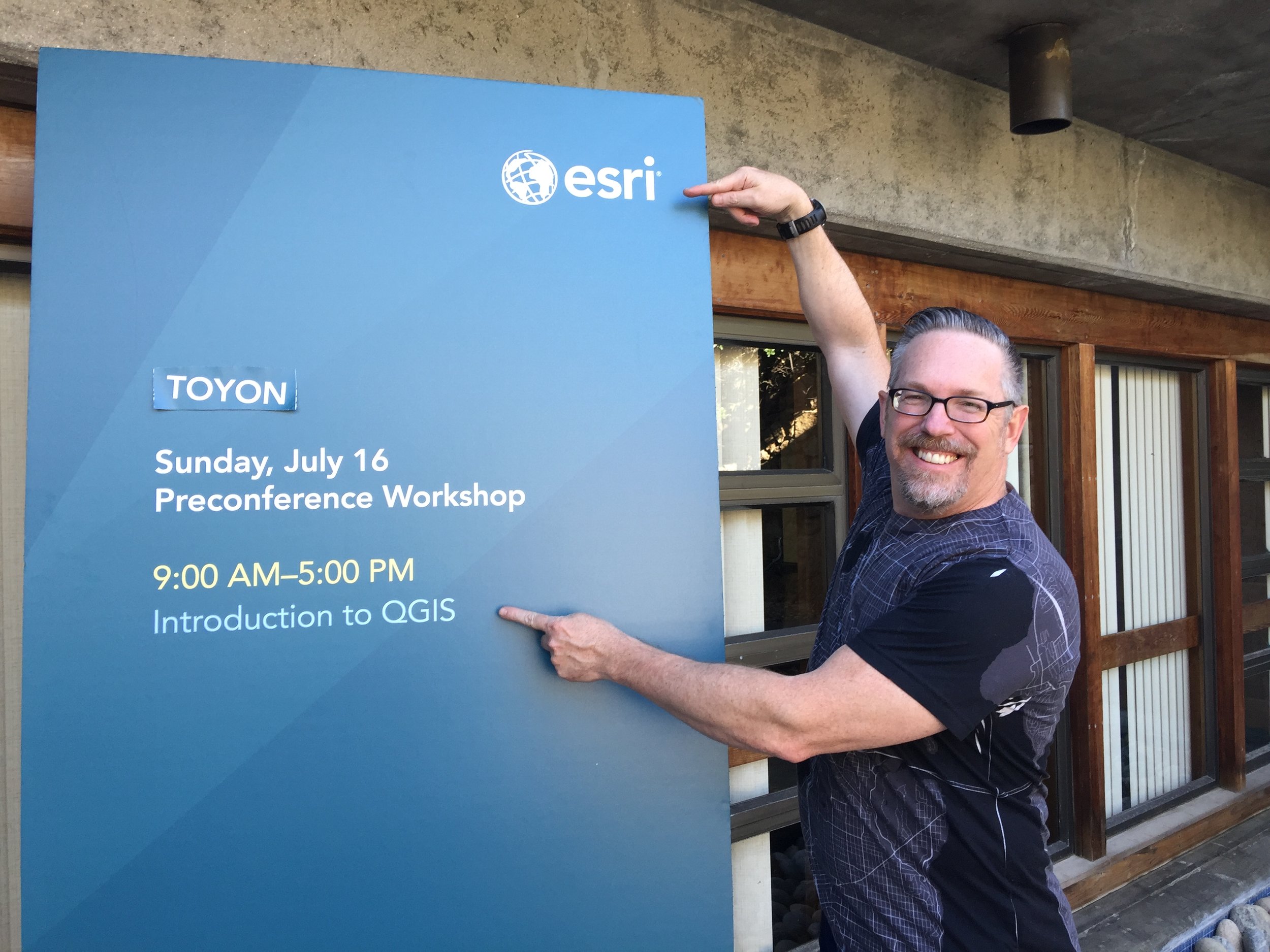
There is an organization named the Society for Conservation GIS (SCGIS). I’ve been part of this for almost 20 years. Twice I even co-chaired the conference committee. It is heavily sponsored by Esri, but is an independent non-profit. Each summer they hold a conference. It is always directly after the big San Diego Esri UC, usually at Asilomar, near Monterey, California. It is an amazing place, over 100 acres of natural beachfront land. As an aside I’ve always thought it would be a perfect place for a QGIS Hackfest. In recent years the Board expressed the desire to be a more inclusive conference regarding the technology included and sponsorship. As part of that they have invited me each of the last three years to teach QGIS workshops. These days there usually a handful of talks at least partly involving FOSS software.
The first year (2017) I taught QGIS I tweeted this photo. The irony was obvious.

SCGIS 2018
The following year when they asked me back they were also in the throes of re-signing an MOU with Esri to sponsor the group for another 5 years. I’m not sure of the amount but it’s a lot. Esri also provides in kind support. Apparently someone at Esri saw this tweet and balked on resigning the MOU. Fortunately it was all smoothed over and the MOU signed. I certainly wasn’t aiming to have the major sponsor withdraw support for the organization.
SCGIS 2019
This used to be one of my favorite conferences to attend. However, over the last several years it has become increasingly uncomfortable. The last two years, I could frequently be found wearing a QGIS or FOSS4G t-shirt. The latter ironically with the Esri logo on the back as a corporate sponsor. I started being the target of snarky rude comments. To some degree I expect and enjoy this. After all, I know most are coming off the high of the big Esri UC. I realize FOSS and Esri people are equally tribal. I then began noticing a trend, people coming up to me whispering under their breath that they use “it” (QGIS) too. Obviously I wasn’t the only one feeling some tension and hostility. Attendees were hesitant to even say QGIS out loud. It was the Voldemort of SCGIS. The software that shall not be named.
2018 SCGIS Group Photo
This trend of snarky comments continued. I began feeling irritated and defensive. More than one person looked at my QGIS shirt and proclaimed, “I can’t believe you have the guts to wear that here!” The last day I had given a talk on the best new features of QGIS 3.x. At the map gallery that evening a gentleman told me he enjoyed it, and then asked, “Did I hear people razzing you during your talk?” Clearly teaching an alternative was threatening. As a long-standing member of this small community (20 years), to suddenly be treated as an invader, simply because I was teaching a QGIS workshop - which I was invited by the Board to teach - felt really ridiculous and petty. My goal is simply to share some cool tools that most in the community aren’t aware of. I am not trying to get everyone to stop using Pro or ArcMap.
I’ve realized there is still widespread ignorance of what open source is. For example, many are surprised to learn that there isn’t a for profit corporation behind a software like QGIS. A session on what open source is, and what it isn’t would be illuminating for SCGIS.
SCGIS Scholars Program
An interesting aspect of the conference is the SCGIS International Scholars program. Scholars are first brought to the Esri UC and then SCGIS. They then get several weeks of Esri GIS courses. On the positive side I always find sitting down and connecting with the scholar’s one of the best parts of SCGIS. There are scholars representing most continents, largely from developing countries.
For me there is also something disturbing about the whole program. It can be seen like a big developing world Esri marketing/indoctrination scheme. While talking to them it’s not surprising to learn that many started out using FOSS4G tools like QGIS. I’ve also noticed that my QGIS workshops aren’t attended by people from the major conservation NGO’s (The Nature Conservancy, The Wilderness Society etc.). Rather more than 50% of the attendees are SCGIS scholars. Seems they realize how important FOSS will be in their communities, especially since many started their careers using it.
As with most things it would be fine if Esri just wasn’t quite so heavy handed. This after all isn’t supposed to be an Esri Scholars program but rather the SCGIS Scholars Program. My feeling is that the whole program would benefit if training’s were done using a variety of software packages. Mono-cultures are not good in nature, and this mono-culture isn’t doing these scholars any favors.
Conclusion
I eventually ended up back in my room, writing a long letter to the Board about my experience there. I told them I doubted I would be back. I spent most of my remaining time at the conference processing the experience with friends and colleagues. I had some really good conversations. There is clearly a division on the board between Esri diehards and those looking to be more inclusive. I sat down with the SCGIS president and an advisory committee member and explained my experience. They were extremely gracious and supportive and a bit surprised. My advice was that they create a code of ethics/conduct for the conference, which doesn’t currently exist. I hear that is in the works. I always feel like Sisyphus pushing the rock up the hill. Some days it’s easier than others.