Public Health

The ASTHO Summit on Climate and Health

During the last week of May I traveled to the island of Oahu in Hawaii to participate in the Association of State and Territorial Health Officials (ASTHO) Insular Area Climate and Health Summit. It was a small intimate meeting organized by ASTHO. It was held at the Ala Moana Hotel with representatives from most of the U.S. territories including:

  • American Samoa
  • Commonwealth of the Northern Mariana Islands
  • Federated States of Micronesia
  • Guam
  • Palau
  • Puerto Rico
  • Marshall Islands
  • U.S. Virgin Islands
  • Hawaii Department of Health 
  • Pacific Island Health Officers Association (PIHOA)

The ASTHO Summit on Climate and Health group photo

The first afternoon was focused on the impacts of climate change, preparedness and building resilience. There were great presentations on climate change (Capt. Barry Choy - NOAA), an overview of the tools and programs available from the CDC (Paul Schramm), and issues around vector-borne diseases and mosquitoes (Janet McAllister). 

Then there were some very humbling and sobering presentations on current issues people are having in the Mariana Islands, Micronesia and the U.S. Virgin Islands. Sea level rise and hurricane recovery were the main topics. I heard first hand, stories of people dealing with climate change impacts now. This was nothing hypothetical. These were real people dealing with catastrophic current impacts. Compounding this were stories of how many islands have such small populations that they frequently fall off federal priority lists.

For example, in Micronesia they are working on a salt water tolerant taro variety. They hope this will help farmers produce food, even with rising seas. The Virgin Islands & Puerto Rico were hit by back-to-back Category 5 hurricanes last September: Irma and then, two weeks later, Maria. Many there are still in survival mode. They used to think of being ready for a week long disaster. They are now planning on months. They need to know basic things, like where all the backhoes are. Climate change is here and the people dealing with the biggest early impacts had very little to do with the cause.

The first afternoon

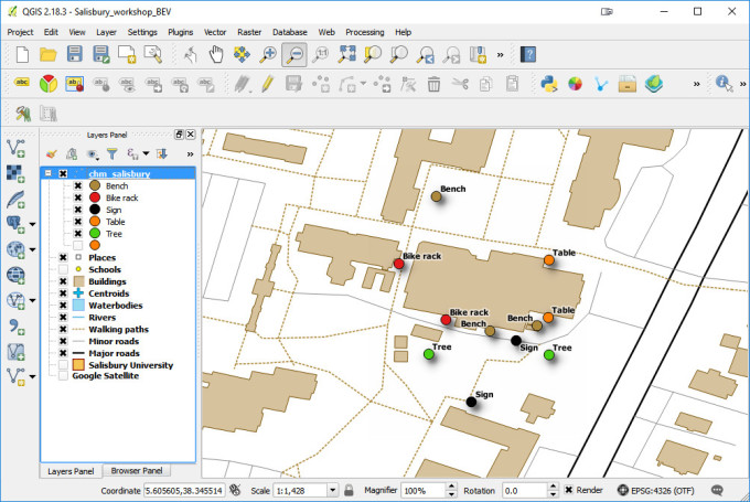
The second day focused more on tools and resources which was why I was invited. There were more detailed talks given by the CDC on vector control, especially from mosquitoes. That afternoon I taught a 3.5 hour Community Health Maps Train-the-Trainers workshop to a group of health officials from each territory. The idea was that they could train their colleagues once back on their islands. We went through the entire CHM workflow: A) how to design a data collection form using Fulcrum, B) how to collect data using smartphones, C) how to make a map in Carto and D) how to bring the data into QGIS.  

Onasai'i Aulava & Ruta Ropeti from American Samoa learning to use Fulcrum

John Tagabuel from the Commonwealth of the Northern Mariana Islands learning to use Fulcrum

The last morning I taught a second Community Health Maps workshop open to everyone. I had about 30 attendees and again went through the entire CHM workflow.

The week was a reminder of how those of us working with technology day-to-day sometimes take it for granted. Everyone was super excited to have this training. It was also a lesson in how resource rich we are on the continent. One of my goals with Bird's Eye View is to use technology to help make the world a better place. (Thus my focus on conservation, public health and education.) One of the goals of the Community Health Maps program is to empower people with technology. This week fulfilled both and was very gratifying.

Most of the trainees had little to no GIS training yet instantly knew how mapping could apply to their work and lives. They want to map everything related to hurricane relief, salt water resistant taro farms, infrastructure related to mosquito outbreaks etc. A benefit of having the community do this is that they can be in charge of their own data and it helps build community relationships. 

One afternoon the officials from American Samoa wanted to see how well the basemaps available in Carto and in QGIS via QuickMapServices represented their home. I opened up OpenStreetMap and zoomed to Pago Pago, American Samoa. It was pretty feature rich and they were surprised and excited. 

2018-06-25_141334.jpg

During the closing session the ASTHO organizers went around the room and asked people to give their closing thoughts. I was amazed to hear person after person say they wanted more training from Kurt. It was great feedback. There seems to be a lot of potential for CHM, and FOSS4G generally, to help U.S. Territories and ASTHO deal with the immediate and long-term health issues related to climate change.

It felt like making real connections with people was easy. That's the way the best meetings/conferences feel. I hope to travel to some of these islands and teach more in depth workshops to get people really up and running with QGIS. I also plugged FOSS4G Oceania and hope some take advantage of the travel grant program!

Farewell shot with my new friends from American Samoa

Coffee, Community Health Maps & My Favorite Coffee Shops Visited in 2016

For the last couple of years I've been working on a project called Community Health Maps for the National Library of Medicine. The goal is to empower public health organizations working with underserved and at risk populations with mapping technology. We aim to help people who don't have backgrounds in computer science or geospatial technology, and don't have budgets for ArcGIS licenses. I've helped develop a program to show these people how they can 1) use Fulcrum to map their communities with smartphones, 2) map that data with Carto and 3) go even further with QGIS. 

Coffee Brewers

Coffee Brewers

This work takes me all over the country teaching half-day workshops. I've got it down at this point. In 3-4 hours I can teach 20-40 people who have never done any kind of map work how to collect data and map the results in Carto and QGIS.

I'm also a coffee geek. I've been hooked by the third wave coffee bug.  I take my coffee seriously as evidenced by my collection of brewers! My wife also compiled the video below of coffee roasters we tried in 2016.

For each training location, I assemble local data from OpenStreetMap and/or local sources. I always include a layer of the local coffee shops to try. After all, I'm going to try them anyway. It's a hobby of mine. Plus it makes it a little more fun, after a few hours of training, to have them open up a QGIS map showing the training location and some coffee shops to try. I usually google 'pour over' coffee in the area, and am sure to exclude all the Starbucks. To me one key to a quality coffee shop is the length of their menu. The shorter the menu the better. For example, I love this menu from Ninth Street Espresso in NYC.

In the last year or so I've been to Charleston 3 times, Seattle twice, along with Spokane, Honolulu, Lawrence, Washington DC and Salisbury MD. I've also been to NYC, Raleigh NC, Portland OR and Denver CO for other business trips. I finally got around to compiling a map of the best coffee shops I've been to in the last year. There are some good ones not on here, these are just the best of the best.

Of these Milstead and Co in Seattle is my favorite. They aren't a roaster but it is simply the best coffee shop I've ever been to. They make each each cup of coffee individually via AeroPress and offer an amazing selection of coffees to try. They are followed closely by Coava in Portland, Toby's Estate in Brooklyn, Black Tap in Charleston, and Boxcar in Denver.  Below are some shots from these coffee shops. Coffee and GIS were made for each other!


Black Tap - Charleston

Milstead & Co - Seattle

Toby's Estate - Brooklyn

Boxcar Coffee Roasters - Denver

Coava Coffee - Portland

If there isn't a good coffee shop I'll bring my Porlex mini grinder, some good beans an my Aeropress. Makes a great cup o' joe in my hotel room! Try it!

A Trip to Maryland to Teach Three Mapping Workshops

Last week I traveled to Maryland. I taught two workshops at the Prince Georges County Department of Social Services for people working on homeless issues. As with most Community Health Mapping workshops, all attendees were novices to mapping technology. However, in the first hour they all built a data collection form in Fulcrum and went outside to collect some data around the building.

Prince Georges County Community Health Mappers

Prince Georges County Community Health Mappers

The attendees represented a variety of organizations including many working with YouthREACH Maryland. REACH is an acronym standing for Reach out, Engage, Assist, & Count to end Homelessness. It is an effort to obtain accurate, detailed information on the number, characteristics, and needs of unaccompanied homeless youth in Maryland. Other organizations represented at these workshops included:

  • Maryland's Commitment to Veterans
  • Maryland Department of Planning
  • Prince Georges Community College
  • St Ann's Center for Children, Youth, and Familes
  • Maryland Multicultural Youth Center
  • So Others Can Keep Striving (S.O.C.K.S)
  • Sasha Bruce Youthwork
  • Lifestyles of Maryland.

In the final two hours of the workshops attendees learned how to map the data they collected in both Carto and QGIS. We also had time for a brief discussion about how CHM could be used in their projects. There were a lot of ideas shared about how the technology could help community engagement.

The afternoon workshop attendees feeling accomplished after completing their Carto maps!

The afternoon workshop attendees feeling accomplished after completing their Carto maps!

After the two PG County workshops, CHM traveled across the Chesapeake Bay bridge to Salisbury University on the eastern shore.

The following morning I taught a workshop geared towards social work students at Salisbury University. Attendees went through the CHM workflow and were introduced to FulcrumCarto and QGIS. Below is a map of data collected around the student center in Carto.

Salisbury University Data Collection in Carto

Salisbury University Data Collection in Carto

The workshop concluded with a short introduction to working with data in QGIS.

Salisbury University Data Collection in QGIS

Salisbury University Data Collection in QGIS

That afternoon I'd hoped to catch up with Art Lembo who wrote How Do I Do That In PostGIS? I realized at the last minute that the author of this little book I've had on my bookshelf works at Salisbury University. Unfortunately he was under the weather. FOrtunately I had time to drive to the Delaware shore for a quick beach walk.

The next scheduled workshop for the Community Health Maps team will be at the Teaching Prevention 2017 Conference in Savannah, Georgia. That conference takes place from April 5-7th. If you are interested in learning this technology this workshop will be a great opportunity!

Announcement: New Community Health Mapping Blog

Community Health Maps - Information on Low Cost Mapping Tools for Community-based Organizations

Kurt Menke, of Bird's Eye View, is contributing to a new FOSS4G related National Library of Medicine blog: Community Health Maps. The goal of the blog is to provide information about low cost mapping tools that can be used by community based public health organizations.  Perhaps you’ve seen the potential uses of mapping in public health, but are overwhelmed by the technology and/or simply too busy to pursue it.  I hope this blog will facilitate the use of GIS mapping for those that fall into this category.  I also hope to support those already engaged in mapping and enhance their community mapping initiatives, even if they may be using other tools.  The blog will be a mixture of mapping apps/software reviews, best practices, and the experiences of those who have successfully implemented a mapping workflow as part of their work. Training materials developed in 2013 are also available.